CAT-05 Flight: Class D to Class D with En-Route Flight Following Pickup
Description
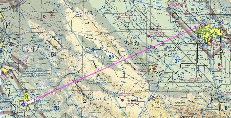
Conduct a flight from Santa Maria Airport (KSMX) to Bakersfield Meadows Field (KBFL) and obtain VFR Traffic Advisories en-route.
Learning objectives
- Review radio communications when operating at Class D airports.
- Review basic VFR navigation skills.
- Learn how to obtain VFR Traffic Advisory Services while airborne.
- Learn about VHF radio limitations with regards to terrain interference and how to mitigate those situations
Flying the Rating
To successfully complete this rating you must accomplish the following tasks:
- Fly from KSMX to KBFL.
- Shortly after departure pick up traffic advisories to KBFL from Santa Barbara Approach.
- Take appropriate action if radio reception with LA Center begins to degrade
- Inform ATC on initial contact at KSMX that you are performing the CAT-5 Rating.
- Meet the CAT Ratings Practical Test Standards
Airspace Review
Both KSMX and KBFL are located in Class D airspace. In order to operate in Class D airspace you must obtain two way radio communications with ATC by calling them and having them reply with your callsign.
Communications Review
VFR Traffic Advisories Overview
VFR Traffic Advisories (commonly known as flight following) is a radar service that is provided by Air Traffic Control facilities for VFR aircraft. It provides VFR aircraft with traffic information.
Flight Following is provided by radar equipped Air Traffic Control Facilities. Generally these types of facilities can be classified as 1 of 2 types.
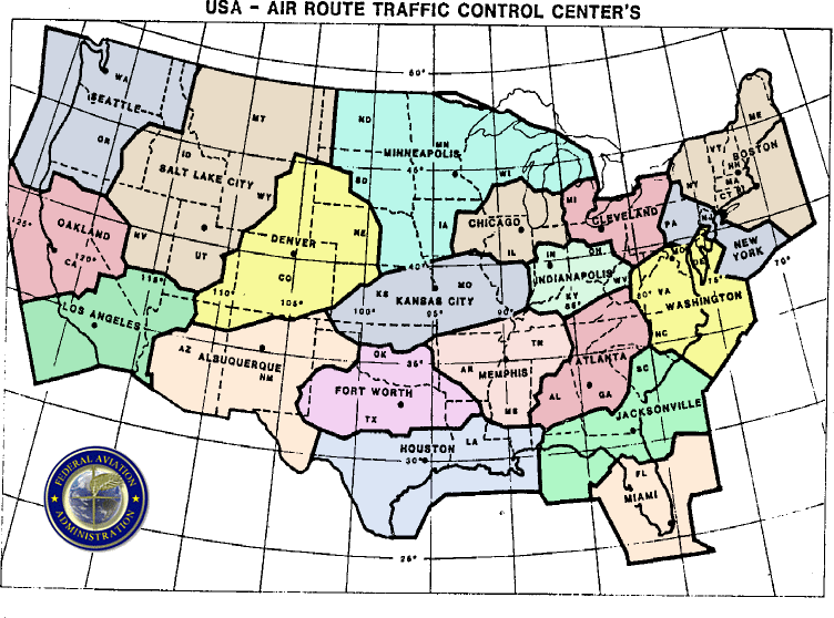
The first is an Air Route Traffic Control Center (ARTCC), commonly referred to as a Center. There are 22 ARTCCs which cover the entire United States.
The second type of radar equipped ATC facility is the Terminal Radar Approach Control Facility (TRACON) commonly referred to as an Approach. TRACONs exist around larger airports and can cover smaller airports near larger airports.
Both ARTCCs and TRACONs can provide flight following services. TRACONs can also provided several other types of radar services to VFR aircraft which will be covered in this flight and in later flights.
Requesting Flight Following
Flight following can be requested on the ground at a towered airport prior to departure or after takeoff. For this flight we will pick up flight following after departure.

In order to pick up flight following you need to know the local frequency for the TRACON or ARTCC facility covering your departure airport. The airport information page for SMX on Skyvector has this information in the Communications section. Otherwise, an official reference would be the Chart Supplement for SMX (also available on the same Skyvector page). Looking at either of these references, we see that the local radar controller frequency is 124.15 with Santa Barbara Approach.
When calling for flight following you should format your initial call as follows:
“(Facility Name), (Callsign), (Position), (Altitude), (Request)”
So for our specific example
“Santa Barbara Approach, Skyhawk 123AB, 10 miles North East of Santa Maria, 7500, request flight following to Bakersfield.”
Air Traffic Control will assign us a squawk code to put in our transponder and shortly there after identify us on radar.
Once we have been radar identified there is nothing for us to do except listen for Air Traffic Control’s transmissions to us regarding traffic or passing us on to another controller.
When you no longer desire flight following simply let ATC know and they will tell you to squawk VFR and send you on your way.
Note that flight following is a workload permitting service. This means that ATC can deny flight following requests or terminate flight following at any time. If this happens you can simply fly the flight without radar services (as we did in the last flight).
Finally, the fact that ATC is providing traffic information does not relieve you of your responsibility to see and avoid other aircraft.
Basic Radar Services
Aircraft arriving into larger airports served by a TRACON have the opportunity to obtain basic radar services. Basic radar services are provided by all TRACON facilities and consists of traffic advisories, limited radar vectoring, and sequencing into the airport.
Basic radar services can be requested in the same way as traffic advisories and are automatically provided to aircraft getting flight following into airports where this service is available.
In our case KBFL offers basic radar services (provided by Bakersfield TRACON). The Chart Supplement provides information on this (look for an R in a circle next to the facility name in the communication section).
When switching to the TRACON that covers your landing airport you should advise them of your intentions at the airport, and that you have the proper ATIS code.
Radio Reception Considerations
It’s usually not possible to have an awareness of the physical location of ATC’s transmitters within the tracon and enroute environment (ie, while talking to SBA Approach or LA Center). A flight at what seems like a perfectly reasonable altitude may encounter VHF reception issues especially with interfering terrain. As it happens, the relevant transmitter for LA Center lies ot the south, blocked by 5100ft mountains. Therefore, if you are cruising at 5500ft, you might expect some line of sight issues to come into play. This provides an EXCELLENT training opportunity and doesn’t necessarily mean that your pre-flight planning was incorrect.
It is important that you be able to recognize that the radio reception is degrading, evidenced by more and more static in the radio broadcasts from ATC, and then take action appropriately. That might require a climb to a higher altitude, or requesting a frequency change to another facility. In this case, an early handoff to Bakersfield Approach might be helpful as their transmitters are (not surprisingly) at Bakersfield, which doesn’t present the same line of sight reception issues when compared to the center transmitters to the south.
Additionally, pilots should monitor GUARD (121.50) on COM2 when able, as recommended by the AIM, and as mentioned in the CAT-1 and CAT-4 ratings. This involves other center transmitters (not located to the south) which might allow you to receive last-ditch efforts by LA Center to reach you. It could be that the reception degraded for too long without action being taken, or perhaps there were no center calls for a longer period of time, during which time the signal strength dropped from “Excellent” to “Oh Dear.” without you having a chance to hear it for yourself.
In summary:
- pay attention to radio signal quality
- plan to climb higher or advise ATC of the poor reception issue, suggesting a frequency change to Bakersfield Approach
- monitor Guard (121.50) on COM2 in case ATC is trying to reach you, or feel free to call Center on Guard if you’ve lost communication
Transcript
VFR departures and arrivals to a Class D airport have been covered in other ratings. Below is an example for the radio transmissions for picking up flight following services and sample en-route transmissions while under flight following services.
When clear of the KSMX Class D airspace you can switch off of tower frequency. Switch to 124.15 to obtain flight following.
N123AB: “Santa Barbara Approach, Cessna Skyhawk 123AB, 10 miles north east of Santa Maria, 7500, request flight following to Bakersfield.”
Santa Barbara Approach: “Cessna 123AB, Santa Barbara Approach, squawk 7110.”
N123AB: “Squawk 7110, Cessna 123AB.”
Santa Barbara Approach: “Cessna 123AB, radar contact, 10 miles north east of Santa Maria, Santa Maria altimeter 29.90.”
N123AB: “Altimeter 29.90, Cessna 123AB.”
Santa Barbara Approach: “Cessna 123AB contact Los Angeles Center on 135.50.”
N123AB: “Contact 135.50.”
Switch to 135.50
N123AB: “Los Angeles Center, Cessna 123AB, level 7500.”
Los Angeles Center: “Cessna N123AB Los Angeles Center, Santa Barbara altimeter 29.91.”
N123AB: “29.91, Cessna 123AB.”
Los Angeles Center: “Cessna 123AB, traffic 2 o’clock 5 miles south bound altitude indicates 6500, type unknown.”
N123AB: “Traffic in sight, Cessna 123AB.”
Los Angeles Center: “Cessna 123AB, Contact Bakersfield Approach, 118.80.”
N123AB: “Contact 118.80, Cessna 123AB.”
Switch to Bakersfield Approach on 118.80. By this time you should have the ATIS for Bakersfield airport.
N123AB: “Bakersfield Approach, Cessna 123AB, level 7500, with zulu.”
Bakersfield Approach: “Cessna 123AB Bakersfield Approach, Bakersfield altimeter 29.80.”
N123AB: “29.80, Cessna 3AB.”
When 10NM From KBFL expect approach to hand you off to tower.
Bakersfield Approach: “Cessna 123AB, contact Bakersfield Tower 118.10.”
N123AB: “Contact tower 118.10, Cessna 123AB.”
Cockpit Video
Related Material
VFR Communications Manual (commercial product) provides detailed guidance on ATC communications for VFR flights.
Airport Traffic Patterns (Wikipedia)
Web site containing scrollable, zoomable VFR and IFR charts
VFR Cruising AltitudesPilot’s Handbook of Aeronautical Knowledge – Navigation
FAA publication on basic and advanced VFR navigation skills.
VFR Flight Planning and Navigation Workshop
YouTube recording of a live workshop conducted by PilotEdge covering VFR flight planning and navigation methods.


